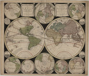
Dutch cartography in its golden age has been run mainly by family firms. After the deaths of Johannes Janssonius (1664) and Joan Blaeu (1672) their family firms sharply declined, and the trade in maps was dominated by five firms, Nicolaes Visscher I and II, the Danckerts family, Frederick de Wit, Carel Allard and Petrus Schenk together with Gerard Valk. They all supplied almost identical products: wall maps and atlas maps. They also all sold atlases, which they compiled from their own and others' maps. Carel Allard (1648-1706) was the son of Huych Allard (d. 1691), who sold maps in the Kalverstraat (the main commercial street of Amsterdam) from 1645, and father of Abraham (1676-1725) who took over his father’s business after his death in 1709. A large proportion of the Allard's copper plates passed to Pieter Mortier, a successful mapmaker who republished the present 1696 map in his 1720 Atlas Minor.

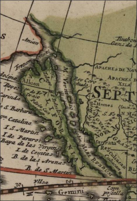
California
The term planisphere used in the title was sometimes used as synonym for world map in general, but more precisely it referred to a world map that had been consciously constructed according to the principles of transformation from a spherical to a flat surface, especially to the mapping of each hemisphere as a circular disk. In modern cartographic terminology this is more commonly referred to as stereographic projection.
The two main hemispheres at the center are the Western Hemisphere (Americas) and Eastern Hemisphere (Eurasia, Africa and Australia). Top center are the Northern hemisphere, bottom center the Southern hemisphere. Top left is a hemisphere with the antipodes of Amsterdam and top right one with Amsterdam as the center. Bottom left is the new world (Americas and the Pacific Ocean) and bottom right is the old world (Africa, Asia and the Indian Ocean).
Symmetrical to the space occupied by the two cartouches at the top with the map’s title in Latin and Dutch, there are two more hemispheres at the bottom: one on the left with the southern hemisphere within the limits of Tropic of Capricorn, and the other on the right with the northern hemisphere within the limits of the Tropic of Cancer.
Four smaller technical spheres at the sides give information on latitudes and longitudes, zenith and nadir.
Sources- Van der Krogt. “Commercial Cartography in the Netherlands with Particular Reference to Atlas Production (16th-18th Centuries).” In La Cartografia dels Països Baixos: Cicle de conferències sobre Història de la Cartografia 4rt curs... Organitzat per l'Institut Cartogràfic de Catalunya i el Departament de Geografia de la Universitat Autònoma de Barcelona, 70-140. Barcelona: Generalitat de Catalunya, Departament de Política Territorial i Obres Públiques, Institut Cartogràfic de Catalunya, 1994.
- Koeman, Cornelis. Atlantes Neerlandici: bibliography of terrestrial, maritime and celestial atlases and pilot books, published in the Netherlands up to 1880. Amsterdam: Theatrum Orbis Terrarum, 1967, vol. 1, 31-32.
- Shirley, Rodney W. The Mapping of the World: Early Printed World Maps 1472-1700. Riverside, CT: Early World Press Ltd., 2001, 578.
- http://publicdomainreview.org/collections/carel-and-abraham-allard-in-the-court-of-momus/#sthash.LjYpXIQY.dpuf
- http://www.donaldheald.com/pages/books/6783/carel-allard/the-world-and-continents-five-maps#sthash.cHlgCd1p.dpuf
- http://en.wikipedia.org/wiki/Stereographic_projection


