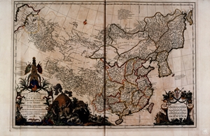
This most comprehensive map was the last drawn by d’Anville for Du Halde. Even though it was first published in 1735, it mainly reflects the situation of the survey taken twenty years earlier, namely the initial stage of the recent territorial expansion of the Qing empire into central Asia, which the Europeans referred to as Chinese Tartary and the Qing as Xinjiang (New Territory) for the Western part and Inner and Outer Mongolia for the Northern and Eastern part.
The map strives to incorporate information from a wide variety of sources. D’Anville was known as a geographe du cabinet (armchair geographer) and considered his responsibility not only to bring the maps to common scale and projection, to insert romanized names in place of the original Chinese characters and to follow the standards of neatness, precision and clarity in nomenclature typical of the French school, but also to check them against the wider possible sources. That applied especially to the scarcely known regions of Central Asia; as the cartouche at the lower left says, the lands between Kashgar and the Caspian Sea were drawn according to Oriental geographers and historians, especially on the 1619 Latin translation of the great thirteenth century Arab geographer Idrisi, misleadingly titled as Geographia nubiensis (‘Geography of Upper Egypt’). Beside that, for these regions D’Anville relied on information from French and Swedish informants in Saint Petersburg, as well as Parisian Jesuits such as Gaubil.
In the tradition of French politic geography, the borders of the empire (and of its provinces and territories) are clearly demarcated by thick hand-colored lines, including Manchuria and part of Mongolia, but leaving aside Tibet and most of Xinjiang. The map includes the whole area between Kashgar and the Caspian Sea, which according to the cartouche at the bottom left is based on “Oriental” (probably Arabic and Persian) geographers and historians.
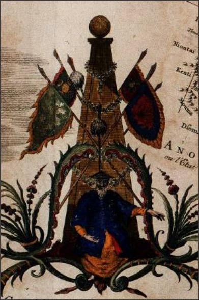
Besides containing the title and the description of the map, the cartouche is adorned by the depiction of the emperor on his throne beneath royal flags. At the side there is a nomadic tent with warriors and women, depicted (like the two warriors on top of the cartouche at the bottom right) according to the chinoiserie style of the time. The cartouche at the bottom right contains also four scale bars displaying differing European measuring systems, asserting its claims to scientific legitimacy.

Throne Beneath Royal Flags
Sources
- Mario Cams, "The China Maps of Jean-Baptiste Bourguignon d’Anville: Origins and Supporting Networks", Imago Mundi: The International Journal for the History of Cartography, Volume 66, Issue 1, 2014, pages 51-69
- Massimo Quaini, Michele Castelnovi, Visioni del Celeste Impero. L’immagine della Cina nella cartografia occidentale, Genova, Il Portolano, 2007, 154-155
- Nebenzahl, Kenneth, Mapping the Silk Road and beyond : 2,000 years of exploring the East, London : Phaidon, 2004, 138-9.
- Semans Cheryl Ann, Mapping the unknown: Jesuit cartography in China: 1583-1773, Berkeley PhD dissertation, 1987: 173-179.
- http://gdz.sub.uni-goettingen.de/dms/load/toc/?PPN=PPN340023538 (downloadable edition of the Atlas)
- https://openlibrary.org/books/OL6935838M/Description_ge%CC%81ographique_historique_chronologique_politique_et_physique_de_l'empire_de_la_Chine_et_ (downloadable edition of du Halde’s Description)
- http://www.wdl.org/en/item/11814/


