Loading...
Home
About
About Rare & Special eZone
Terms of Use
Collections
Antique Maps of China
Ancient East Asian Maps
Maps of China, Late Qing Dynasty-1949
Rare Books on History of Science
Western books about China before 1949
James Lee Collection
Paul Lin and Soong Ching-ling Correspondence
Paul T. K. Lin’s Hsinhua Photo Collection
Sha Fei Photographic Collection
Chinese books before 1949 (Thread Bound)
Chinese books before 1949
HKUST Library Artwork
HKUST Posters
Walter R. Kent Collection
HKUST Electronic Theses
Results:
Modify search
region:Sri Lanka
x
Thumbnail
List
Sort By:
Relevance
Title
Year Ascending
Year Descending
Displaying results 1 - 2 of 2
Tabvla Asiae XII
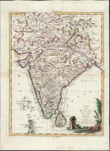
Stato del Mogol con l'isole di Ceilan e ...
Tabvla Asiae XII
MAP
[Publisher not identified] , between 1540 and 1552
1 map ; 24 x 21 cm
Antique Maps of China
Stato del Mogol con l'isole di Ceilan e Maldive
G. Pitteri, scr
MAP
Presso Antonio Zatta , 1785.
1 online resource (1 map : hand colored)
Walter R. Kent Collection
Displaying results 1 - 2 of 2
Advanced Search
Expand all
Collapse all
Collection
(1)
Antique Maps of China
(1)
Walter R. Kent Collection
Year published
(1)
1540
(1)
1785
Geographic region
(2)
Sri Lanka
(1)
Asia
(1)
India
(1)
Maldives
Map maker
(1)
Münster, Sebastian, 1489-1552
(1)
Pitteri, Giovanni Marco, 1702-1786
(1)
Ptolemy, active 2nd century
(1)
Zatta, Antonio
(1)
Zatta, Antonio, active 1757-1797