The Blaeu were the most successful cartographic publishers of the seventeenth century, an age when Netherlands rose to become the foremost trading and exploratory nation of the West. Willem Janszoon Blaeu started the family business in printing and mapmaking in the early 17th century and became official mapmaker for the Dutch East India Company. His son Joan, originally trained as a lawyer, joined the family business and in 1638, following his father’s death, took both the firm and the position of official mapmaker for the Company, coming to dominate Dutch mapmaking, even though in constant competition with the other main Dutch cartographic dynasty of the times, the Hondius-Janssonius family. Joan outdid his competitors with his 11-volume Atlas Maior, completed in 1662, with more than 3,000 pages of text and 600 illustrated maps, one of the largest and most expensive books ever printed.
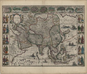
This map of Asia from the 1664/65 edition of Joan Blaeu’s Great Atlas was first published by Willem Blaeu as a loose sheet in 1618. Willem based it upon his own wall map of 1608, which in turn drew on Hondius's folio map of 1606. China is represented as more elongated and narrower than its true shape, following Ortelius’ and Hondius’ maps; Korea is represented as an island and Taiwan is roughly in the right place and size, but represented as a stretch of smaller islands. Even though the image of Asia and especially of China reflected in this map is definitely much less precise than the Martini’s 1655 map of China also published in Blaeu’s Atlas, it became one of the better known maps of Asia of the 17th century, mainly due to its striking style and decorations.
Costumed figures
The map is decorated at the sides with ten vignettes, five on the left and five on the right side, each with two pairs of costumed figures, from Arabians and Armenians in the West to Chinese and Tartarians in the East. The images come from two great Dutch illustrated travel collections, Jan Huygens van Linschoten’s Itinerario and Theodor de Bry’s Petits Voyages, both of which included detailed accounts of the East Indies.

Macao
On the upper border there are nine city views: Kandy (Sri Lanka), Calicuth (South India), Goa, Damascus, Jerusalem, Ormuz, Bantam, Aden and Macao. Beside the biblical reference to Jerusalem, dutifully at the centre as in traditional maps, all the others are famous trading cities. The images are partly based on Braun and Hogenberg’s famous city atlas Civitates Orbis Terrarum (Cologne 1572-1617).

Lion

Sea monster

Camel
The map is decorated by sea monsters in the empty corners at the right top and center bottom, as well as by camels, lions and elephants in uncharted land areas. At the centre of China is depicted, as quite usual since Ortelius’ 1584 map, a wind wagon.
The Dutch text on the back gives a general outline of the Asian continent, first discussing the etymology of the name Asia and then praising its importance in Ancient and Biblical History. The continent is then described in its subdivisions and borders, first based on the Classical description by Ptolemy, then referring to the contemporary division into five parts, as shown by different colors on the map: Turkish Empire, Persian Empire, India, China and Tartary. Finally, the main rivers and cities are listed and briefly described, using both classical and contemporary names.

Elephant

Sea monster

Wind Wagon
Sources
- Goss, John, Blaeu’s The Grand Atlas, New York: Rizzoli 1990, 190-191.
- Koeman, Cornelis, Joan Blaeu and his 'Grand atlas'. Amsterdam: Theatrum Orbis Terrarum, 1970.
- Brotton, Jeremy, A History of the World in Twelve maps, London: Penguin 2012, chapter 8.
- Blaeu, Joan, Atlas maior of 1665, Köln; Los Angeles: Taschen, 2010, 35 (on the dates of the Dutch edition of the Atlas)
- http://digibug.ugr.es/handle/10481/3421#.VNGYM2iUd8E (Blaeu’s Atlas volume on Asia, with Latin Text)
- http://european-heritage.org/netherlands/alkmaar/dutch-cartography-17th-century
- http://www.cartography.henny-savenije.pe.kr/blaeu.htm
- http://historic-cities.huji.ac.il/mapmakers/braun_hogenberg.html
- http://www.antiqueprintroom.com/catalogue/print-print?id=2816af9b4d694efb46002c16e163a25b&catalogid=44ce0393622f48fba189f879174c5873&sessid=142020de61afa347cecf8569de40445f
- http://www.cartography.henny-savenije.pe.kr/blaeu.htm
- http://www.swaen.com/antique-map-of.php?id=18405


